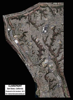
One cold, wintry day here in Podunk Missouri, I set about to make an aerial map of where I was born and raised until I left the nest to “shack up” with my then girlfriend – now forever wife, Jill, ’76. That place, of course, is Clairemont.
I spent my entire childhood living in the house at 4262 Moraga Avenue (between Balboa and Clairemont Mesa Blvd.) I attended Cadman Elementary with many of you and matriculated along the way to both Marston Junior and Clairemont High.
Through the miracle of Google Maps, I made screen captures (several hundred) of small sections of Clairemont neighborhoods and “wove” them together using Photoshop. When it was uploaded to the yearbook website it shared a bonus “effect” that I wasn’t counting on.
Once you access the “full resolution zoomable image” you can now click on a particular landmark (i.e. CHS or the Square) and that’s where you will begin your tour. To go somewhere else in Clairemont, click once again on the aerial to return it to the original un-zoomed size, and now you can click on another landmark (like maybe your neighborhood.) You may have problems with the aerial if you have your browser set to higher than 100% zoom.